
WHAT IS A RAPID INVENTORY?
Field Museum rapid inventories are cooperative, rigorous surveys of the biological and cultural assets of a priority landscape for conservation.
Our inventories focus on vast landscapes with high potential for conservation: often remote, megadiverse, and lacking formal protection. Requests for inventories have come from local communities, research institutes, NGOs, and regional and/or national governments. We respond to these opportunities by forming inclusive partnerships, collecting new field data to boost and complement existing knowledge, and collectively generating recommendations to mobilize action for conservation and the wellbeing of local people.
Broad collaboration forms the essence of our inventories. We work with stakeholders at all levels—from host-country and international scientists, to local villagers, to government agencies and civil society—to build on already-existing efforts, elevate local and regional expertise, and gather crucial biological and social information. Constructing the inventory with partners from the start is crucial, as it cements common goals, clarifies roles, and ensures that the inventory results translate directly into action.

Photo by Jorge García Melo
Impact
Our rapid inventories have generated critical insights into some of the planet's most biodiverse and culturally rich regions, elevated local residents as key partners in land management, and strengthened environmental governance at multiple scales. It has helped establish 24 new conservation areas across Peru, Ecuador, and Bolivia and provided vital information for large areas in Guyana and Brazil.


Where we work
The Rapid Inventories team has conducted 34 inventories since 1999, the majority of which (27) have taken place in the Andes-Amazon region. Six were conducted in Cuba and one in China. The Andes-Amazon is one of the most biologically and culturally diverse regions in the world, and it is also where many of the most promising conservation opportunities are, due to the longstanding stewardship of these territories by Indigenous and local peoples.
Methods
Together with our partners we follow a series of steps:
-
Map major habitats and outstanding ecological features, local communities and governance structures, current and historical conservation and management efforts, and key decision-making entities.
-
Build institutional agreements, secure proper permits, and consult local communities to determine how an inventory can best serve the local vision for stewarding the landscape. Using this early engagement and our maps of the area, we identify the sites to be visited.
-
Conduct fieldwork.
-
Synthesize data and present information to key decision makers in pursuit of the most important outcomes for conservation and quality of life.
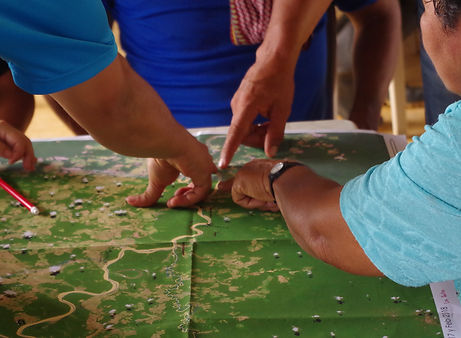
Photo by:

During the biological portion of the fieldwork, scientists and long-term residents survey plants, fishes, amphibians, reptiles, birds, and mammals — organisms that indicate habitat type and condition and that can be surveyed quickly and accurately. Our inventories do not attempt to produce an exhaustive list of species or higher taxa. Instead, these surveys identify the species, natural resources, and landscape features with high conservation value (at global, national, or local scales), assess the conservation status of those assets, and document threats.
Photo by Álvaro del Campo
During the social portion of the fieldwork, a diverse group of social scientists, government officials, representatives from non-governmental organizations, and local leaders collaborates with local communities to identify patterns of social and political organization, natural resource use, and relationships between local people and outside entities. The teams use participant observation, semi-structured interviews, focus groups, participatory mapping, and other action research methods to quickly identify the assets of local communities that can serve as points of engagement for long-term participation in conservation, as well as the threats that local people and natural resources face.

Photo by Diana Carolina Alvira

Photo by Ana Alicia Lemos
As soon as field work is complete, we present preliminary findings to local people and in-country decision-makers. We then translate everything we’ve learned into practical recommendations for achieving long-term conservation. These often include a recommendation to establish a new park or reserve co-managed by local peoples, in addition to steps for maximizing local autonomy and quality of life, and for mitigating threats. In the months and years following the inventory, we work with in-country partners to share the team’s recommendations, reports, and other products with local and international decision-makers, who set priorities and take conservation action.
The research
The team synthesizes its findings in Rapid Inventory reports, reports and presentations to stakeholders, and scholarly publications. We share not only the data we collect on inventories, but the implications these data have for protection and management in these areas. Data collected on rapid inventories have been used in more than 130 peer-reviewed scientific publications to date.
In a 2021 paper in Science Advances, our team shared our approach through a case study of the state of Loreto, Peru, where conservation coverage has quadrupled in the last 20 years. From 2000–2016, biological and social scientists worked to increase the protected proportion of Peru’s largest department via 14 interdisciplinary inventories covering >9 million hectares of this megadiverse corner of the Amazon basin. In each landscape, the strategy was the same: convene diverse partners, identify biological and sociocultural assets, document residents’ use of natural resources, and tailor the findings to the needs of decision-makers. Nine of the 14 landscapes have since been protected (5.7 million hectares of new protected areas), contributing to a quadrupling of conservation coverage in Loreto (from 6 to 23%). We outline the methods and enabling conditions most crucial for successfully applying similar campaigns elsewhere on Earth.
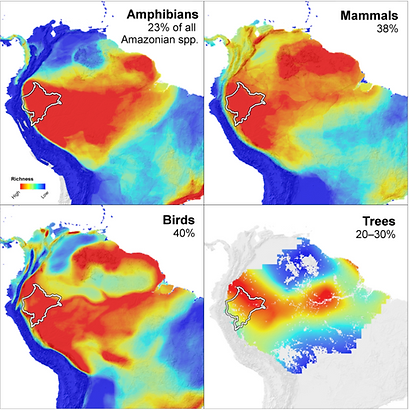
These maps illustrate the distribution of species richness of four taxonomic groups across South America from highest (red) to lowest (blue). The white border outlines Peru’s Loreto region, which accounts for five percent of the Amazon basin’s area. Percentages in each panel indicate the proportion of all Amazonian species expected to occur in Loreto.